Murphys/Columbia Environs - April 27-30, 2000
(Posted May 19, 2000, © Herbert E. Lindberg)


Below is a map of the region Val and I toured on foot Friday morning while Sandy and Mary shopped on Main Street. The shopping area extends from Dunbar House west to the left boundary of this map.
.

Map of Murphys and Environs
Created with Streets98 --- http://www.maps.expedia.com
and LivePix 1.1 --- http://www.livepix.com
Scale: 0.6 miles across entire map


Val and I began our tour by walking east from Dunbar House on Jones Street. There are several interesting homes on both sides of the street, as described in the Murphys Walking Tour and Map that we picked up at Dunbar House. We turned right at Cemetery Lane and walked up the hill to the cemetery. On our right were beautiful green pastures that we looked down on.
.

Very small part of Murphys cemetery


When we arrived at the cemetery we were surprised by its size. We guessed that the population of the dead was about ten times the current population of Murphys. The next day we learned that there is another surprisingly large cemetery at the Catholic Church. From the names and dates on the tombstones (dating back to the gold rush), coupled with the names and history associated with the homes and stores in the Tour Map, we could piece together the larger scope of Murphys families. Religious preferences ran the gamut from Protestant, to Catholic, to Jews and many more.

We spend at least an hour wandering around the cemetery reading tombstones and spotting monuments to the town's past leaders. The tombstone of an old mule skinner told of his life, complete with misspelled "their."
.

Tombstone of an old Mule Skinner


The west border of the cemetery is at the edge of a steep hill overlooking a valley with pine trees beyond. As I walked down the road approaching this view I was struck by the three-dimensional vista, with the road and near trees in the foreground and the valley and far trees in the background. So I took a stereo pair of pictures, given below. You can't get the stereo effect directly on your screen because the pictures are farther apart than your eye separation.

Stereo pair of view looking west from cemetery


But if you're familiar with how to free view stereo pairs, copy this pair to your favorite photo software (word processors like Microsoft Word will also do the job) and print them out at your printer's highest quality. They should print at a 5-inch width for the pair, corresponding to a typical eye separation of about 2.5 inches. If you've never tried this before you should; it's lots of fun. Just look at the pictures and stare past them to infinity, which will cause the pictures to overlap and eventually snap into a three-dimensional picture in your mind.

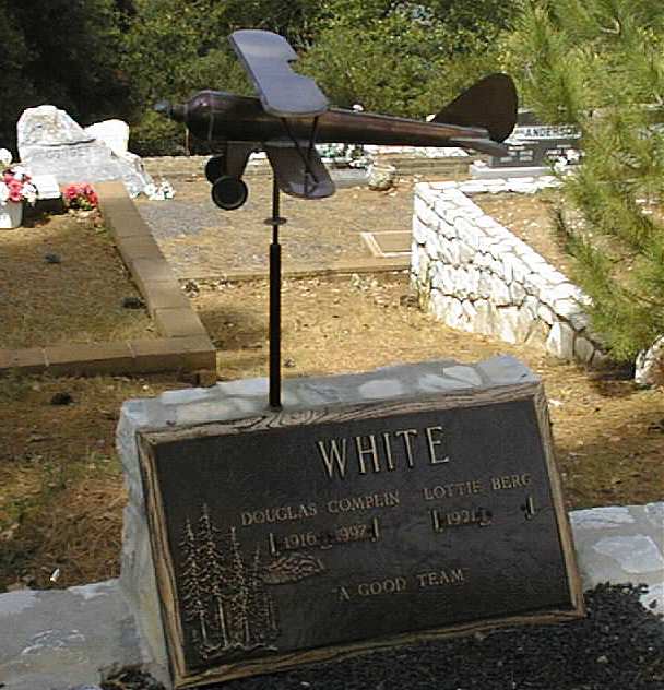
At the crest of the cemetery (just past the right tree in the above pictures) was this tombstone with a brass airplane, poised as if to take off from the cliff and over the valley. Douglas died in 1997 at the ripe old age of 81, and Lottie is still kicking at 79. I wonder if she flies over in a light plane?
.

Airplane Tombstone

A long-loving couple


At right is the tombstone of another long-loving couple: 60 years. This engraver seemed to be the most popular in the past 20 years or so, as evidenced by the many stones of this material and lettering style.


We continued our tour by returning north on Cemetery Lane, then west on Jones Street, and south on Scott Street. As we walked along Scott we saw some homes with the pastures that we had viewed from Cemetery Lane. The picture below has one of these pastures in the background.
.

Herb at field on Scott Street, west of the cemetery


From Scott Street we turned right onto Algiers, heading northwest back towards downtown Murphys. An old miner's shack appeared on our right, in an area untouched since the gold rush.
.

Shack viewed from Algiers Street


Right along Algiers Street in front of the shack was a large collection of rocks (you can see another in the lower right corner of the shack picture). If you look closely these rocks have obviously been worn by water. I thought maybe the creek that runs through Murphys once ran here but later learned that these rocks are evidence of the extensive hydraulic mining around Murphys. Knowing this, we saw them all over the region, most notably near the old barn just west of town on Main Street. In back of the barn is evidence of the miners re-directing the flow of the creek for use in hydraulic mining.
.

Rock debris from hydraulic mining
Farther along Algiers Street on the left we came upon the Black Bart Theater. We read a notice on the door that the play Ravenscroft was nearing the end of its run and would play that night, no advanced tickets required. After dinner the next day (Friday) we went to the theater, bought tickets ($5 each) and saw the play. It was wonderful -- a mystery-comedy with six players, all very good. The humor was of the type in Arsenic and Old Lace as the detective tried to find who murdered a young, handsome handyman who had some kind of affair with all five ladies in the house.

City Hotel in Columbia


We continued on up Algiers Street, back to town to see the old two-cell jail, and then on to Dunbar House for some wine and snacks. That evening (Thursday) we had a gourmet meal at the City Hotel in Columbia, a repeat performance of last year's visit to the area.


Congregational church, 
at Church St. and Sheep Ranch Rd.


Val and I continued our tour by bicycle the next day. We came soon to the Congregational Church.


A few blocks up the hill north on Sheep Ranch Road is the Catholic church.
.

Catholic church off Sheep Ranch Road


After looking at the hydraulic mining evidence in back of the barn west of town on Main Street (Murphys Grade) we headed down Algiers Street, which becomes 6 Mile Road, on the way to re-visit the Ironstone Winery. The picturesque barn and poppies along the road caught my fancy.
.

Barn east of 6 Mile Road on the way to Ironstone Winery


Near the entrance to Ironstone they have an old steam farm tractor on display. I wonder how many of these were made? Not many would be my guess, because it was a big, expensive monster that must have taken more skill and daring that a typical farmer would want to learn. And the driver sits right in back of the firebox -- wow, talk about a hot day on the farm! And where was the tender with fuel?
.

Steam Tractor


The picture below is evidence that Ironstone completed their entertainment stadium, which was just a rocky field last year.
.

The Ironstone stadium is completed.


Saturday we drove to Columbia on our way to the DeMartini Fish Fry, to which we were invited by Bob and Joan DeMartini Coker. Columbia is a state park swarming with tourists, not my cup of tea. I couldn't resist snapping this picture of overweight tourists on the Columbia Stagecoach.
.

Tourist stagecoach in Columbia

Return to Murphys Hub Page - | - Go to Home Page