| USD Campus Map and Tram Guide |
 |
University of San Diego Campus Tour
Photos taken Monday, October 27, 2003
© 2003, Herbert E. Lindberg
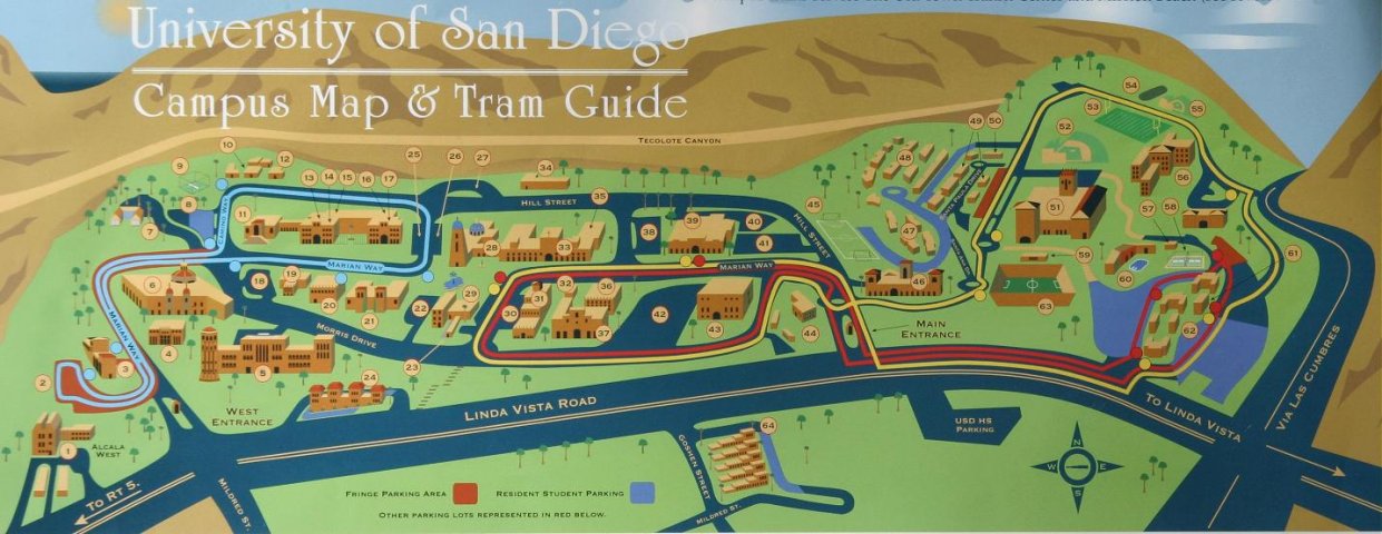
These Web pages give a brief glimpse at the beauty and architecture on the University of San Diego Campus. Immediately below is the Campus Guide available at the University, for example at the main entrance guard station. Scroll back and forth to get a complete picture of the campus. Below the map is a listing of the buildings and other structures, keyed to the numbers on the guide.
| USD Campus Map and Tram Guide |
|
| 1. School of Education 2.West Hill Parking Lot 3. West Parking Complex 4. Casa De La Paz 5. Shiley Science Building 6. Kroc Institute for Peace & Justice 7. Casa De Alcala 8. Copley Parking Lot 9. West Tennis Courts 10. Chemistry & Marine Science Labs 11. Copley Library 12. Facilities Management Complex 13. Shiley Theater 14. Camino Hall 15. Health Center 16. Sacred Heart Hall 17. Founders Hall |
18. Olin Parking Lot 19. Olin Hall 20. Manchester Conference Center 21. Hahn School of Nursing 22. Hughes West Lot 23. Public Safety, Parking & Visitor Information 24. Presidio Terrace Apartments 25. Immaculata West Lot 26. Immaculata East Lot 27. Immaculata North Lot 28. Immaculata Church 29. Hughes Administration Center 30. Hughes East Lot 31. Serra Hall 32. Guadalupe Hall |
33. Maher Hall 34. Print Shop 35. Salomon Hall 36. Warren Hall Law School 37. Loma Hall Center 38. University Center West Parking Lot 39. Hahn University Ctr. 40. University Center North Parking Lot 41. University Center East Parking Lot 42. Law School Lot 43. Pardee Legal Research Center 44. Degheri Center 45. Sports Field 1 46. Missions Parking Structure |
47. Missions B 48. Missions A 49. Seminary 50. Kolbe Center 51. Jenny Craig Pavillion 52. Cunningham Baseball Field 53. Sports Field 2 54. Sports Field 3 55. Softball Field 56. Manchester Village 57. Weight Room 58. East Tennis Courts 59. Field House 60. Sports Center/Pool 61. Palomar Lounge 62. Alcala Vista Apts. 63. Torero Stadium 64. University Terrace Apartments |
Photographs of most of the buildings in the campus center are given on three additional Web pages. You can proceed to these pages to download the pictures as you read associated text by clicking on the links at the bottom of this page. Alternately, or after you've had this first scan through the pictures, you can click on the red-circled numbers in the campus center map below to jump to the associated building. By jumping back and forth between the map and pictures you can take a virtual tour of the campus center. Sometimes there is more than one picture of a building, so, after viewing the picture you jump to, scroll down the page to see if there is another. When you hover your cursor over any of the building numbers below (red-circled or not) a pop-up box will appear with the name of the associated structure.
| Map of Campus Center, with Links to Building Photographs |
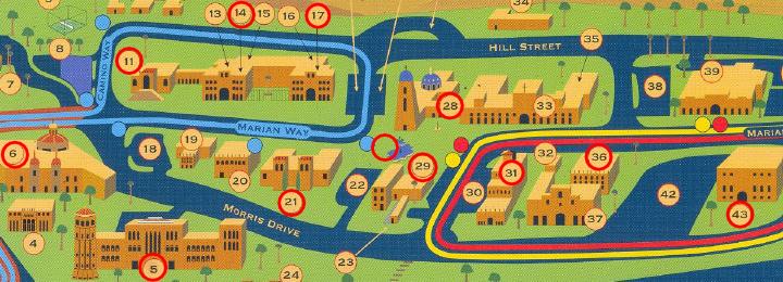 |
Immaculata Church | Buildings West of Church | Buildings East of Church